Mississippi Vector Map Isolated - stock illustration
Detailed vector map of Mississippi with administrative divisions. File was created on June 5, 2013. The colors in the .eps-file are ready for print (CMYK). Included files: EPS (v8) and Hi-Res JPG (3811 × 5600 px).

Get this image in a variety of framing options at Photos.com.
PURCHASE A LICENCE
All Royalty-Free licences include global use rights, comprehensive protection, and simple pricing with volume discounts available
$500.00
+GST NZD
Getty ImagesMississippi Vector Map Isolated High-Res Vector Graphic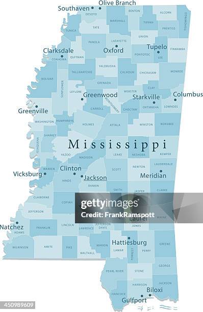 Download premium, authentic Mississippi Vector Map Isolated stock illustrations from Getty Images. Explore similar high-resolution stock illustrations in our expansive visual catalogue.Product #:450989609
Download premium, authentic Mississippi Vector Map Isolated stock illustrations from Getty Images. Explore similar high-resolution stock illustrations in our expansive visual catalogue.Product #:450989609$500+GST$50+GST
Getty Images
In stockDETAILS
Credit:
Creative #:
450989609
Licence type:
Collection:
DigitalVision Vectors
Max file size:
3290 x 5057 px (34.82 x 53.52 cm) - 240 dpi - 4 MB
Upload date:
Release info:
Model and property released
Categories:
- Mississippi,
- River Mississippi,
- Map,
- Gulfport,
- Pearl River - Southern USA,
- Biloxi,
- Blue,
- Cartography,
- Clip Art,
- Coastline,
- Colour Image,
- Computer Graphic,
- Digitally Generated Image,
- Gulf of Mexico,
- Hattiesburg,
- Illustration,
- Jackson - Mississippi,
- Lake,
- Latitude,
- Longitude,
- No People,
- Non-Urban Scene,
- Physical Geography,
- Plain Background,
- River,
- Satellite View,
- Sea,
- Southern USA,
- USA,
- Vector,
- Vertical,
- Vicksburg,
- View Into Land,
- White Background,